 |
| The 'old lighthouse' atop Cape Point – a case of seeing is believing ... |
Showing posts with label lighthouse. Show all posts
Showing posts with label lighthouse. Show all posts
Sunday, October 16, 2011
Not the Cape Point Lighthouse

Friday, March 27, 2009
Places Beginning with "B" ...

Click to enlarge...
From Buffels Bay, we head north across a scrubby, rocky beach littered with dried kelp, a couple of large, featureless dunes, a cross commemorating Vasco Da Gama — the fat cat and sometime sailor who gave the Cape its name, and an abundance of unremarkable undergrowth.
Why my apparent distaste for this particular place? Its delights are documented well enough below, but the main reasons for my lack of enthusiasm are the peaks towering over False Bay. From the sea, they form a vertiginous barrier to any thought of landing but, from experience, I know the coastal strip running along their base as one of the most challenging, rewarding, and dangerous walks in the Cape of Good Hope Nature Reserve.
But we'll get there. For now, we leave Buffels Bay and the visitors centre at Busffelsfontein, head off to further braai spots at Bordjiesrif, some of the Cape's most amazing surf at Black Rocks, and investigate the lime kiln under Paulsberg at Booi se Skerm. With a detour to Kanonkop to take in the view.
And because we've not many photos to look at, we might as well glance back in time to the original lighthouse at Cape Point — in 1860. Looks kinda different, eh?
Dunes, rocks and sandy beaches in a picturesque setting combine to make Buffels Bay a popular recreational area. ... Reserve management policy demands that recreation which is not strictly compatible with conservation, but allows for an acceptable diversity of utilisation by visitors, should be focused on a small number of appropriate sites. This minimises the need for disturbance and development in the rest of the reserve. Thus we have parking areas, rolling lawns, a tidal swimming pool, braai places and ablution blocks at the bay. Although inevitably detracting from the natural qualities of the reserve, such facilities are essential to cater for a broad spectrum of demands from visitors. Carefully planned and controlled, the infrastructure need not necessarily introduce suburbia into the wilderness. Very busy over the summer holiday season, Buffels Bay is all but deserted for the rest of the year. This is a lovely spot, and it is easy to see why it is so popular with the picnickers and paddlers. Present day visitors are not the first to appreciate the area — it has a long history of human occupation and utilisation, from vegetable farming to whaling. Today's users are, hopefully, more sensitive than their predecessors. As recently as the 1960s a fishing encampment was installed amongst the dunes. The domestic refuse emanating from this informal settlement has been largely removed, but a variety of material still surfaces from time to time. Chop bones and sea shells reflect the preferred diet of these latter-day strandlopers, an abundance of beer bottles their liquid leanings.I'd recommend this book for its content, but not for its writing. The author uses "utilise" twice in the first paragraph, inserts “hopefully”, describes the place as "lovely", and speaks of "beckoning beds of kelp".
A second relatively intensively developed area not far away is Bordjiesrif. Again, the swimming pool and picnic spots are very busy in the summer, particularly over Christmas and New Year. At other times, there is little but the gulls to disturb the tranquillity of the boulder beaches and beckoning beds of kelp.
Further along the False Bay coast, the road runs along the foot of the hills and limestone outcrops to Booi se Skerm. We are told that years ago this was a veritable woodland of coastal shrubs and trees. A few remain, including an important relict patch of kloof forest, but most were chopped down to provide fuel for the local limekiln. Recently restored, this sits with a certain robust dignity under the outcrops which supplied its raison d'etre. The small caves in the cliffs are known as Booi se Skerm, or 'Booi's Shelter'. This stretch of coast loses the sun quite early, being almost oppressively overshadowed by the mountains, but, whoever Booi was, he and previous occupants (who may date back thousands of years) f the caves chose a retreat which affords the finest views of False Bay and the mountains beyond and received the warming sun first thing in the morning.
Michael Fraser and Liz McMahon | Between Two Shores
Urk! Let's get to the picture show ...
Sunday, March 15, 2009
Cape Point's Lighthouses

Click to enlarge...
I suppose we'd better get the tourism stuff over with and visit Cape Point lighthouse — the replica lighthouse at the top and the operating lighthouse on the rocks below.
Many visitors, and Capetonians, are unaware that the lighthouse "up top" is a facsimile built on the base of the original iron tower, erected in 1860. The old light, at 2,000 candlepower, relied on 16 metallic silvered reflectors and a 12-seond beam every minute to light a path for ships around the Cape of Good Hope. It saw 50 years of service, but was declared inadequate following the sinking of the 5,537 ton Portuguese liner, the Lusitania, which struck Bellows Rock in 1911.

Today, the "old" lighthouse has no light and serves as a control centre for all South African lighthouses. A plaque at the Dias lookout point between the two sites offers the following information of the "new", inaccessible brick-and-mortar lighthouse, commissioned 90 years ago, on March 11, 1919:
Operating Lighthouse 1919
The lighthouse below is the most powerful on the south African coast. This site, at 87 metres above sea level, was chosen to avoid the frequent cloud and mist that covered the original lighthouse, behind you on Cape Point Peak. The original light was a paraffin vapour mantle of 500 000 candlepower which was electrified in 1936. The light has an intensity of 10 000 000 candlepower, a range of 63 kilometres, and gives three flashes every three seconds.

As for the area, Heather Valence relates the memories of one of the "new" lighthouse's early residents:
One of my first memories was of Cape Point lighthouse, the old tower which was turned into a watch room for the light keepers. I would walk up to the tower to visit my father and from there wander about as wild and free as the Cape Point reserve animals. I feared only the cobras because they made no friends.
When I was growing up the only tourism Cape Point saw was the occasional Cape Town sightseer, lots of Japanese visitors and pilots paid to fly out the dead from the Belgium Congo. The only shop was a small kiosk run by my mother at the bottom of the hill. She sold sweets and cold drinks and cigarettes.
Japanese tour guides supplied their clients with food they ate while looking out to sea. Baboons raided the visitors’ day packs but left the sushi for reasons only baboons understood. I was fascinated with the left over sushi as everything in our house was cooked to death before it was served and eaten.
A work shift in the lighthouse perched on cliff below consisted of two men who trekked up and down the precarious footpath in sunshine and gales, summer and winter, twice a day.

Note: This blog will take shape slowly over the next few weeks. For now, like every blog, it remains very much a work in progress.
Wednesday, March 11, 2009
Beside the Point


Click to enlarge...
Do we need an introductory entry? I suppose, although the little 'about' block at top right just about sums it up, we do — if only to try out this template and figure out how to embed this, that, and the next thing. Mixing XML and HTML does not feature highly on the list of things being second nature to me.
OK, it's in the nature of the place, I guess. Cape Point Nature Reserve, that is. Most people visiting the reserve head straight to the south-western tip of Africa on the slightly claw-shaped headland hosting Cape Point, Dias Point, Cape Maclear, and the Cape of Good Hope. The rocky promontory giving the Cape of Storms its name and the reserve itself are synonymous. For many, there is little else to find there.

Click to enlarge
Until you look about you. Cape Point then becomes a fascinating mix of oft-seen, infrequently visited, and generally obscure places of magic and wonder, most often wandered by locals in search of solitude. Through this blog, we'll visit all these spots — the known and lesser known, but at a different time and pace from that set by your average tour guide.
The typical guide, it seems to this usually shabbily dressed local frequently seen stomping through the crowds thronging the parking area, appears preoccupied with getting his charges to the toilets, giving them 30 minutes to head to the replica lighthouse atop Cape Point, and hustling them down to the Cape of Good Hope — there to have their photographs taken standing behind a sign demarcating the continent's south-westernmost piece of real estate.
That's after they've surveyed the walk up to the lighthouse; have consulted whatever it is they use to tell the time, and have settled for having their pictures taken alongside a sign proclaiming baboons to be dangerous — which they're not if treated with respect.

Click to enlarge
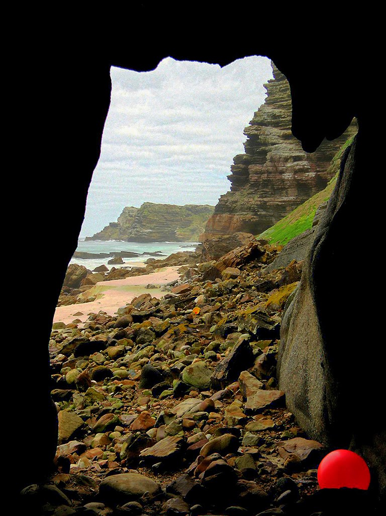
Peter Slingsby's excellent map of Cape Point names each promontory and marks the spot under Dias Point on which the Iranian barge, the Shir Yib, came to rest in July 1970. More importantly, Slingsby points to the caverns under our point of focus, sea caves with which I became fascinated after taking my first photographs from the top close on three years ago. I've used a few shots of the Dias Point Cave to illustrate this entry.

Over three years, I've used two digital cameras; the Canon Powershot A520 and S3 IS. Today, they're decidedly "low end" and their capabilities are far beneath those of the cheapest SLR. Which lack of capability, it should be noted, says a lot for Cape Point. It knows no technical limitations and will offer any camera stunning shots at the squeeze of a button.

Click to enlarge
Reached by way of a short walk from Dias beach on the western side, the caves, carved out of rock laid 450 million years ago, lie beneath occasionally richly vegetated, soaring sea cliffs and the replica lighthouse atop them. Because their access depends on a notoriously fickle swell, a denuded beach and the tide, Dias Point Cave offers a solitude far removed from the crowds surveying the south Atlantic from the headland above.
Click to enlarge
Although you can visit the main cave only in the best conditions — and armed with local knowledge and a low tide, there are caves and aptly contorted rock formations further towards the point. Should you be unable to visit them, chill out in the main cave, which offers a window on to an ocean over which myriad seabirds circle, swoop and glide.
Although only 45 minutes' walk from the top, the caves are usually inaccessible. Do not try to visit them. In all likelihood, you'll find yourself caught between Dias Point and Cape Point with a rising tide facing you, sheer cliffs at your back, and nowhere to hide. The sea is alarmingly powerful and often deadly.

Click to enlarge
The boom of the Shir Yib, a proud, triangular span of heavy steel just a year ago, is today a twisted mess of flattened metal forming a featureless tangle among the gigantic rocks littering what can be an extremely inhospitable and unforgiving shore.
Must Read Dias Point Cave by Sean Houghton and Bruce Stevens in Full Circle Magazine's December 2007 issue. As for Bruce's photographs ... Eish!
Subscribe to:
Posts (Atom)