Monday, March 30, 2009

Cape Point: Venus Pool ...

Cape Point: Venus Pool ...
Click to enlarge...

The gated, tarred road leading from Booi se Skerm to Venus Pool has become increasingly overgrown over the past few years. I like it that way. Fewer people wander down to the inappropriately named natural tidal pool on the rocks under Paulsberg. It's not that I mind families making full use of an ideal picnic spot and natural wonderland at the risk of perhaps a slip on a rock or a dousing by the sea. Venus Pool's easy access worries me because it forms the gateway to the The Coves, a treacherous walk along the coast and one of Cape Point's most compelling attractions. Despite my deeply ambivalent feelings for this stretch, I want it for myself ...

For now though...

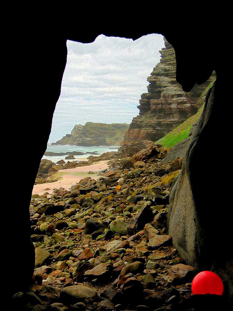
...from Booi se Skerm the land climbs to the mountains along a rocky coast covered by marshland, pools, thick grasses and a few remaining thickets of the forest that once covered the area. It's a stunning coast, along which you can easily spend a day exploring nooks, crannies, weird rock formations, anemones, limpet shells, kelp forests, and any number of sealife forms. Towards Venus Pool and deeper beneath the immense shadow cast by Paulsberg's sheer and craggy face, The Cauldron, a small, block-shaped cutaway from the coast roils and thunders, throwing huge plumes of spray high above any onlooker wise enough to be aware of where the spray might fall.

The Cauldron is symptomatic of my frustration with this coast. It's position, rocks, and topography militate against easy point-and-click photography. I've very few pictures of the place and fewer that I like. The Cauldron's impossible to photograph in a manner that does justice to its raw violence. Facing seawards, it's all but invisible and a camera cannot capture the height of the waves flung to the gulls and terns wheeling and cawing overhead. Side on, getting close to it when the swell booms in is nigh on impossible but, if you do, catching the dark coast plays havoc with any light setting. The mountains too, i.e. Paulsberg, De Boer and Judas Peak usually have the sun above or to their right and throw sharp, unyielding contrasts.

I've considered dropping in at the visitor's centre at Buffelsfontein to suggest the place be painted a more camera-friendly colour, but so far I've desisted. And so it remains a challenge.

The tarred road — a ten-minute amble, ends in a parking area hammered by a storm in September 2008. The steps leading down to Venus Pool have broken away and nature's reclaimed her domain. Best during an incoming tide — when aquamarine swells smash the ledges and launch themselves landwards, the dark, constantly washed rock slabs are ideally situated for an experienced eye to assess the coast stretching to Judas Peak and Batsata Rock. They're also ideal for fishing and mark the start of a protected zone.

Any assessment of an extended walk is likely to underestimate its difficulty. Cliffs, coves, crags, boulder-strewn beaches and sheer drops meld and merge to an illusory conformity from Venus Pool to Judas Peak and, while a visit to the former's two neighbouring coves might be feasible, walking any further demands extreme caution and a guide.

We'll head down that way shortly but, for now, Venus Pool. Surely somebody can come up with a better or more descriptive name. "The Slabs"? "Surrender all hope ..."?

Love was surely never as unforgiving.

Saturday, March 28, 2009

Cape Point: Local Colour

Cape Point: Local colour ...
Click to enlarge...

Cape Point: Local colour ...
Click to enlarge...

Cape Point: Local colour ...
Click to enlarge...

Cape Point: Local colour ...
Click to enlarge...

I was down at the Point for sunrise this morning and, though the light was lousy, played with colours. More, with a panorama here and an HDR there — they're about 800 KB each, a few hours under the cliffs showed a point-and-click can do pretty much anything normally attributed to a digital SLR.

Not that that makes me feel any better ...
Although only 45 minutes' walk from the top, the caves are usually inaccessible. Do not try to visit them unaccompanied by a local or guide. In all likelihood, you'll find yourself caught between Dias Point, Cape Point and a rising tide, sheer cliffs at your back, and nowhere to hide. The sea is alarmingly powerful and often deadly.

Friday, March 27, 2009

Places Beginning with "B" ...

Places Beginning with "B"
Click to enlarge...

From Buffels Bay, we head north across a scrubby, rocky beach littered with dried kelp, a couple of large, featureless dunes, a cross commemorating Vasco Da Gama — the fat cat and sometime sailor who gave the Cape its name, and an abundance of unremarkable undergrowth.

Why my apparent distaste for this particular place? Its delights are documented well enough below, but the main reasons for my lack of enthusiasm are the peaks towering over False Bay. From the sea, they form a vertiginous barrier to any thought of landing but, from experience, I know the coastal strip running along their base as one of the most challenging, rewarding, and dangerous walks in the Cape of Good Hope Nature Reserve.

But we'll get there. For now, we leave Buffels Bay and the visitors centre at Busffelsfontein, head off to further braai spots at Bordjiesrif, some of the Cape's most amazing surf at Black Rocks, and investigate the lime kiln under Paulsberg at Booi se Skerm. With a detour to Kanonkop to take in the view.

And because we've not many photos to look at, we might as well glance back in time to the original lighthouse at Cape Point — in 1860. Looks kinda different, eh?
Dunes, rocks and sandy beaches in a picturesque setting combine to make Buffels Bay a popular recreational area. ... Reserve management policy demands that recreation which is not strictly compatible with conservation, but allows for an acceptable diversity of utilisation by visitors, should be focused on a small number of appropriate sites. This minimises the need for disturbance and development in the rest of the reserve. Thus we have parking areas, rolling lawns, a tidal swimming pool, braai places and ablution blocks at the bay. Although inevitably detracting from the natural qualities of the reserve, such facilities are essential to cater for a broad spectrum of demands from visitors. Carefully planned and controlled, the infrastructure need not necessarily introduce suburbia into the wilderness. Very busy over the summer holiday season, Buffels Bay is all but deserted for the rest of the year. This is a lovely spot, and it is easy to see why it is so popular with the picnickers and paddlers. Present day visitors are not the first to appreciate the area — it has a long history of human occupation and utilisation, from vegetable farming to whaling. Today's users are, hopefully, more sensitive than their predecessors. As recently as the 1960s a fishing encampment was installed amongst the dunes. The domestic refuse emanating from this informal settlement has been largely removed, but a variety of material still surfaces from time to time. Chop bones and sea shells reflect the preferred diet of these latter-day strandlopers, an abundance of beer bottles their liquid leanings.

A second relatively intensively developed area not far away is Bordjiesrif. Again, the swimming pool and picnic spots are very busy in the summer, particularly over Christmas and New Year. At other times, there is little but the gulls to disturb the tranquillity of the boulder beaches and beckoning beds of kelp.

Further along the False Bay coast, the road runs along the foot of the hills and limestone outcrops to Booi se Skerm. We are told that years ago this was a veritable woodland of coastal shrubs and trees. A few remain, including an important relict patch of kloof forest, but most were chopped down to provide fuel for the local limekiln. Recently restored, this sits with a certain robust dignity under the outcrops which supplied its raison d'etre. The small caves in the cliffs are known as Booi se Skerm, or 'Booi's Shelter'. This stretch of coast loses the sun quite early, being almost oppressively overshadowed by the mountains, but, whoever Booi was, he and previous occupants (who may date back thousands of years) f the caves chose a retreat which affords the finest views of False Bay and the mountains beyond and received the warming sun first thing in the morning.

Michael Fraser and Liz McMahon | Between Two Shores
I'd recommend this book for its content, but not for its writing. The author uses "utilise" twice in the first paragraph, inserts “hopefully”, describes the place as "lovely", and speaks of "beckoning beds of kelp".

Urk! Let's get to the picture show ...

Monday, March 23, 2009

Cape Point: Buffels Bay ...


From Antoniesgat, a short stroll north along the Meadows under Matrooskop brings you to Buffels Bay and the Suikerbrood tidal pool. Cape Point's only easily accessible beach and close to ablution facilities and the Buffelsfontein visitors' centre, Buffels Bay is not my favourite place.


It's full of people and, where you find people and baboons interacting, people generally misbehave.
Tour operators and tourists caught baiting baboons so they can take pictures of them will be criminally charged, the City of Cape Town said on Monday.

"Any tour operator caught doing so can be charged under national conservation legislation," said the city's executive director for the environment Piet van Zyl in a statement.

"We appeal to the public to exercise extreme caution in interacting with baboons. Under no circumstances should they ever feed the animals and should they do so, they can be similarly (sic) charged," he said.

He was responding to newspaper reports according to which tour operators were throwing food onto the roadside to attract baboons for their clients to photograph.


Along with bontebok and ostrich, you'll find a troop of Chacma baboons at Buffels Bay. A sociable and polite bunch (the baboons — ostriches have no social skills), they give the lie to the signs littering Cape Point, i.e. 'Baboons are dangerous'.

Our local primates can be dangerous when indulging habits taught them by humans, e.g. mugging walkers or hijacking cars. A couple of years’ ago I had a bottle of Coke ripped off me from behind and, more recently, watched as two women, enjoying tea on the beach, had their little niceties spread across the South Peninsula.

But I love the buggers, their two-inch canines and bark that separates you from your skin when ambling along some ostensibly deserted ridge or plain. Given due respect — in short, treat them as you'd be treated — baboons make for damned fine company.


If you can get down to Buffels Bay early or on a weekday, you'll probably find it deserted. With braai facilities stretching back to The Meadows, it's an ideal spot to kick back, watch the sea, and burn some meat. Just keep a wary eye on those baboons — or they'll be the ones eating it.

Sunday, March 22, 2009

Cape Point: Antoniesgat ...


I've spent much time at Antoniesgat; not because its history is still being written, revised and embellished, but because it's a remarkably beautiful, rugged, and isolated spot. Reached from the Rookrantz parking area (heading north) or Buffels Bay (heading south), it comprises the start of the orange and red sea cliffs leading to Da Gama Peak and Cape Point. Both approaches from the main path are marked as being dangerous, but knowledge of the area makes them less so.


The stories surrounding Antoniesgat originate in Dutch colonial history, eighteenth-century slavery, and the nearby Simon's Town Muslim community. In 2007, Martin Weltz's noseweek turned its investigative reportage to the War of the Red Kitaab.
"She was born Juleigha Anthony, a daughter of what she claims is the oldest Muslim family in Simon's Town. She says her granny used to tell a spook story involving a slave ancestor named Antonie, brought to Simon's Town in chains by the Dutch and locked in a dungeon. According to legend, Antonie escaped, stole a boat and sailed away to Cape Point, where he took refuge in a cave. The Dutch could never catch him, because he was a Sufi mystic who could make himself invisible. As a child, she was taken to his hideout, which the family called Antoniesgat. Powerful spirits seemed to lurk nearby ...”

"Circa 2001, Juleigha met Ebrahiem for the first time. Prior to this, Ebrahiem had never heard of Antonie, but he liked the story, especially the bit about escaping from Dreaded Slave Dungeons. He put two and two together and decided that Antonie and Prince Ismail of Sumbawa were probably the same person. His grounds for this are somewhat shaky. We do not know that Antonie really existed, and Prince Ismail is also shrouded in mystery. Ebrahiem says the oral history of Sumbawa mentions such a man but his name does not appear in the records of the Dutch East India Company, which is odd. The Dutch usually made quite a fuss of royal exiles, providing a stipend that enabled them to maintain a dignified lifestyle.

But Ebrahiem was not concerned about the lack of corroboration, because the oral histories of oppressed people are just as valid as records kept by imperialists, not so?"

more ...
 

No matter how intricately woven the colourful web of suppositions surrounding Antoniesgat may become, nothing can detract from its unspoilt natural beauty and isolation. In this last sense, it is indeed a "spiritual" place.

Saturday, March 21, 2009

Rooikrans II


Bowed by the ages and shaped to an amphitheatre facing the sun, the third and lowest ledge at Rooikrans (or Rooikrantz) is all but inaccessible. Aeons are bared in the multicoloured rock strata looming above a stage featuring an age-old rockfall and a lavatory offering an extraordinary view.


One of Cape Point's most visible landmarks, Lavatory Ledge is frequently photographed but seldom visited.


Whereas a walk at Rooikrans generally comprises meandering down through the strata marking time's slow passage across the foot of Africa, the three main sea-level fishing ledges are sheared, separated from each other by steep, tricky rock faces.


The steps to the lowest ledge start at the highest by way of a fifteen-foot wall scaled at the risk of a fall to the unforgiving rock of the middle ledge below. The wall has adequate foot and handholds, but you need to be shown them by an experienced fisherman. If you've no head for heights, don't try it.

A fall will almost certainly mean broken bones, a costly helicopter evacuation, and other people putting their lives in danger to pluck you from the cliff face.


Dropping from the middle to the lower ledge would be more tricky were it not for a handily placed rope that allows you to climb down and under the middle ledge, allowing for an easy drop on to Lavatory ledge.

Deserted, it's an awesome place. Aware of its visibility from further along the coast or across False Bay, its solitude is tangible. At low tide, it’s possible to explore the mussel beds, rocks and pools beneath the shade-giving ledge.


The toilet? I don't know, but I suspect bored fishermen of yesteryear. Bringing it, the piping, and suitable rocks in by boat should have been no problem. The joy — laced with brandy, Coke, fish and much laughter, must have been in its building rather than any relief it afforded.


Fittingly, the lavatory is not visible from any point away from the ledge and, if that proves anything, it's that the devil is always in the detail.

Friday, March 20, 2009

Rooikrans I


In every Capetonian's lineage is a male relative or antecedent renowned for spending much of his waking life on the ledges at what was once Cape Town's premier fishing spot, Rooikrans — or Rooikrantz.

A short walk south of the Rooikrans parking lot and a scramble down the red-rock cliffs might have you stopping in your tracks to see two or three silver spinners, each tracking the other, snaking far out to sea before disappearing beneath the heaving swell, only to be reeled in immediately. An unwary yellowtail would see three silver flashes and instinctively launch itself at the hook. Fish are not easily landed on the ledges and gaffes are long and expertly wielded.


The casting continues all day.

Passing a fully laden fisherman on his way down late one afternoon, I asked him if he intended fishing or "fishing". "Neither," he responded. "I just need to get away from the wife."

It's that kind of place.


Climbing down to the ledges, you'll soon learn that it's an extraordinary person who frequents Rooikrans, a person for whom I have great respect. No-one illustrates this better than another sometime visitor to the ledges, muso, poet, surfer and fisherman Robin Auld, whose essay Rooikrantz is worth reading in full.
There was, according to the weekly angling report in the Argus, a run of yellowtail at Rooikrantz. Yellowtail are not caught too often by surf fisherman like myself. You need to spin for them at places where you have access to deep blue water, places where rock falls sheer into the ocean. Rooikrantz, just inside the tip of Cape Point in the Good Hope reserve, is rated one of the best. Never having been there I decided to give it a try. The morning after the report I drove to the reserve, paid at the gate and headed to the small car park above Rooikrantz where several cars were already parked. The stony path leading down the mountainside is very steep, it tacks its way down by running at a shallow gradient and then changing direction sharply to come back the other way.

It took me about forty-five minutes to get down to Rooikrantz. The path arrived at sea level not quite at the spot, having to bypass the red cliffs that seemed to overhang the actual fishing area. There was quite a swell running. It seemed that you were standing next to the open ocean, and in a sense you were. The swells came in from the deep, lifting the blue up ten feet or so against the rock and then sucking back, not breaking onto the rocks but sweeping past and heading into the bay. There were five or six men sitting on a large, flat rock some way back and up from what seemed to be the best spot. Their rods were lying, unattended, close to the water. Some way down there were a few anglers spinning from some precarious looking perches. Their silver spoons sparkled out in arcs against the sky before splashing down and barreling back through the water like tiny torpedoes.

Nobody was catching anything. The fishing area seemed to have an amphitheatre feel to it, as if it was the setting for something. The massive cliffs that formed the backdrop seemed to curve around us and any sound, even a kicked stone, echoed and reverberated around the rock arena.

more ...
Do yourself a favour. Read this story. We'll get round to the pictures and Lavatory Ledge later ...

Tuesday, March 17, 2009

Da Gama Peak ...


Any number of pictures of the old buildings above the hikers' cabins on Da Gama Peak would prove boring. Unless they were shot under a psychedelic sky … or ablaze … or photoshopped to something else. They're public works buildings of the first order, probably belonging to the same group built across the point during WWII.

In fact, they are. Following my finding the stamp of the South African Army Corps of Engineers on one of the WWII radar station pillboxes down at the point, I'd rooted around Google and discovered Da Gama Peak's small building to have had similar origins.

Offering respite from the shade on a hot day, they epitomize the short amble up Da Gama Peak from the Rooikrans parking lot. Singularly uninspiring, it appears to be a Cape Point anomaly, an instance of featureless similarity marring countless natural wonders. "Never mind," I thought, sitting on a rock overlooking the northern sector of the park, "At least I can say I've been here."


I guess you can go anywhere and see nothing. Sitting there, I realised Da Gama Peak's extraordinary value. It's a lookout second to none. If you click on the picture above, you'll begin to discern virtually every point on the Cape Point map. You won't, for example, see Sirkelsvlei, a large natural body of fresh water to the northwest. Nor will you see places hidden by the point's numerous capes and coves.

It's nevertheless a stunning overview leading to a greater mystery. How the hell does so much fit into one picture?

Rockhopping back to the peak before descending the circular path overlooking the point, I wondered at my having invested two years of scrambling, walking, and crawling in that view. By the time I reached the car park — visible at centre-bottom, I felt invigorated and kept on walking, down to Rooikrans ...
Who was this Vasco Da Gama for whom so many South African memorials were erected and after which so many of the Cape's places are named? According to Wikipedia, he was a fat cat and sailor of sorts ...

Monday, March 16, 2009

Another Side of Cape Point ...


Click to enlarge...

A while back — give or take several hundred thousand to untold millions of years, a massive section of the south-eastern side of Cape Point (next to the parking area) broke away and crashed into the ocean. Left to the wind and tides, the jagged rock smoothed to a gentle bulge and later a flat ledge at the base of the peninsula. In short, a divers' paradise replete with galjoen, hottentot, red roman, steenbras, and yellowtail.

Having scrambled down the fiendishly hidden path to the left of the parking area, i.e. away from the restaurant, the first things you'll notice on the rocks are the crayfish shells. These shells explain the almost-certain presence of a well-hidden ranger in the area and, although you might not mind wandering a short coast beneath several hundred tourists — none of whom seem to glance down, you'll feel watched.


That feeling — antithetical to the Cape Point spirit and oblivious to 65 kmh winds, saw me scrambling pointwards up what I assume to be Plumpudding Rock, a large outcrop slowly detaching from the main cliffs. About 150 feet up, I came across a plateau or ledge overlooking the eroded section. The wind and sea, borne on the southeaster, have bored into the face of the mountain, forming a deep, extremely steep cove.


It's stunningly beautiful and, as if to improve on perfection, a rock already detached from the mainland is visible further south. Although the outer contour of the southerly rock follows that of the point, it's as though a giant, neatly shaped wedge has been excised from it, leaving it orphaned from the land.


Given an assortment of oddly coloured rocks on its summit and years of guano covering its bulk, it's very obviously shaped like a penguin, standing and looking up at the point it's just abandoned.


The rock is paradoxically hard to see given its prominence when viewed head on. Not visible from the parking area at the foot of the old lighthouse — Plumpudding Rock obscures it, it doesn't leap out at you from the Lighthouse Keeper's path farther south. And from the sea — you can see it clearly from The Coves across False Bay, it merges with the cliffs alongside it.
I guess very few people get to see it. And it's probably a good thing. That drop to the coast sends my stomach plummeting to my boots on thinking of it. The south-easter howls around the point and slams directly into the rockface. Getting a couple of shots demands crawling out along the spur and the gale renders a camera live. It lurches and bucks and can be clicked only between violent gusts.
I climbed the rest of the way up and, it seems, over the hill, bumbled around some ugly, windblasted rockfaces, and eventually crashed through the trees looking for all the world like a local resident to confront several startled tourists halfway up the hill to the old lighthouse.


"Penguin Rock," answered the ranger scanning the coast for crayfish poachers from the parking area on my asking the feature's name.

Sunday, March 15, 2009

Cape Point's Lighthouses


Click to enlarge...

I suppose we'd better get the tourism stuff over with and visit Cape Point lighthouse — the replica lighthouse at the top and the operating lighthouse on the rocks below.

Many visitors, and Capetonians, are unaware that the lighthouse "up top" is a facsimile built on the base of the original iron tower, erected in 1860. The old light, at 2,000 candlepower, relied on 16 metallic silvered reflectors and a 12-seond beam every minute to light a path for ships around the Cape of Good Hope. It saw 50 years of service, but was declared inadequate following the sinking of the 5,537 ton Portuguese liner, the Lusitania, which struck Bellows Rock in 1911.


Today, the "old" lighthouse has no light and serves as a control centre for all South African lighthouses. A plaque at the Dias lookout point between the two sites offers the following information of the "new", inaccessible brick-and-mortar lighthouse, commissioned 90 years ago, on March 11, 1919:
Operating Lighthouse 1919

The lighthouse below is the most powerful on the south African coast. This site, at 87 metres above sea level, was chosen to avoid the frequent cloud and mist that covered the original lighthouse, behind you on Cape Point Peak. The original light was a paraffin vapour mantle of 500 000 candlepower which was electrified in 1936. The light has an intensity of 10 000 000 candlepower, a range of 63 kilometres, and gives three flashes every three seconds.


As for the area, Heather Valence relates the memories of one of the "new" lighthouse's early residents:
One of my first memories was of Cape Point lighthouse, the old tower which was turned into a watch room for the light keepers. I would walk up to the tower to visit my father and from there wander about as wild and free as the Cape Point reserve animals. I feared only the cobras because they made no friends.

When I was growing up the only tourism Cape Point saw was the occasional Cape Town sightseer, lots of Japanese visitors and pilots paid to fly out the dead from the Belgium Congo. The only shop was a small kiosk run by my mother at the bottom of the hill. She sold sweets and cold drinks and cigarettes.

Japanese tour guides supplied their clients with food they ate while looking out to sea. Baboons raided the visitors’ day packs but left the sushi for reasons only baboons understood. I was fascinated with the left over sushi as everything in our house was cooked to death before it was served and eaten.

A work shift in the lighthouse perched on cliff below consisted of two men who trekked up and down the precarious footpath in sunshine and gales, summer and winter, twice a day.

Note: This blog will take shape slowly over the next few weeks. For now, like every blog, it remains very much a work in progress.

Wednesday, March 11, 2009

Beside the Point


Click to enlarge...

Do we need an introductory entry? I suppose, although the little 'about' block at top right just about sums it up, we do — if only to try out this template and figure out how to embed this, that, and the next thing. Mixing XML and HTML does not feature highly on the list of things being second nature to me.

OK, it's in the nature of the place, I guess. Cape Point Nature Reserve, that is. Most people visiting the reserve head straight to the south-western tip of Africa on the slightly claw-shaped headland hosting Cape Point, Dias Point, Cape Maclear, and the Cape of Good Hope. The rocky promontory giving the Cape of Storms its name and the reserve itself are synonymous. For many, there is little else to find there.


Click to enlarge

Until you look about you. Cape Point then becomes a fascinating mix of oft-seen, infrequently visited, and generally obscure places of magic and wonder, most often wandered by locals in search of solitude. Through this blog, we'll visit all these spots — the known and lesser known, but at a different time and pace from that set by your average tour guide.

The typical guide, it seems to this usually shabbily dressed local frequently seen stomping through the crowds thronging the parking area, appears preoccupied with getting his charges to the toilets, giving them 30 minutes to head to the replica lighthouse atop Cape Point, and hustling them down to the Cape of Good Hope — there to have their photographs taken standing behind a sign demarcating the continent's south-westernmost piece of real estate.

That's after they've surveyed the walk up to the lighthouse; have consulted whatever it is they use to tell the time, and have settled for having their pictures taken alongside a sign proclaiming baboons to be dangerous — which they're not if treated with respect.


Click to enlarge

Peter Slingsby's excellent map of Cape Point names each promontory and marks the spot under Dias Point on which the Iranian barge, the Shir Yib, came to rest in July 1970. More importantly, Slingsby points to the caverns under our point of focus, sea caves with which I became fascinated after taking my first photographs from the top close on three years ago. I've used a few shots of the Dias Point Cave to illustrate this entry.

Over three years, I've used two digital cameras; the Canon Powershot A520 and S3 IS. Today, they're decidedly "low end" and their capabilities are far beneath those of the cheapest SLR. Which lack of capability, it should be noted, says a lot for Cape Point. It knows no technical limitations and will offer any camera stunning shots at the squeeze of a button.


Click to enlarge

Reached by way of a short walk from Dias beach on the western side, the caves, carved out of rock laid 450 million years ago, lie beneath occasionally richly vegetated, soaring sea cliffs and the replica lighthouse atop them. Because their access depends on a notoriously fickle swell, a denuded beach and the tide, Dias Point Cave offers a solitude far removed from the crowds surveying the south Atlantic from the headland above.


Click to enlarge

Although you can visit the main cave only in the best conditions — and armed with local knowledge and a low tide, there are caves and aptly contorted rock formations further towards the point. Should you be unable to visit them, chill out in the main cave, which offers a window on to an ocean over which myriad seabirds circle, swoop and glide.
Although only 45 minutes' walk from the top, the caves are usually inaccessible. Do not try to visit them. In all likelihood, you'll find yourself caught between Dias Point and Cape Point with a rising tide facing you, sheer cliffs at your back, and nowhere to hide. The sea is alarmingly powerful and often deadly.

 Click to enlarge

The boom of the Shir Yib, a proud, triangular span of heavy steel just a year ago, is today a twisted mess of flattened metal forming a featureless tangle among the gigantic rocks littering what can be an extremely inhospitable and unforgiving shore.
Must Read Dias Point Cave by Sean Houghton and Bruce Stevens in Full Circle Magazine's December 2007 issue. As for Bruce's photographs ... Eish!